Comprehensive BIM Solutions: Elevating Project Efficiency
Building Information Modeling (BIM) is a process that is fundamentally transforming the construction industry by creating a digital representation of a physical asset to be used throughout its lifecycle. This process is powered by an intelligent 3D model, which acts as a single source of truth by integrating multi-disciplinary data on a cloud platform. The true power of this workflow is its ability to bridge the gap between the physical and digital worlds. By seamlessly connecting state-of-the-art reality capture hardware with advanced modeling software, it transforms raw site surveys and as-built data into accurate and actionable BIM models, thereby driving significant gains in efficiency and precision from initial planning to long-term facility management.
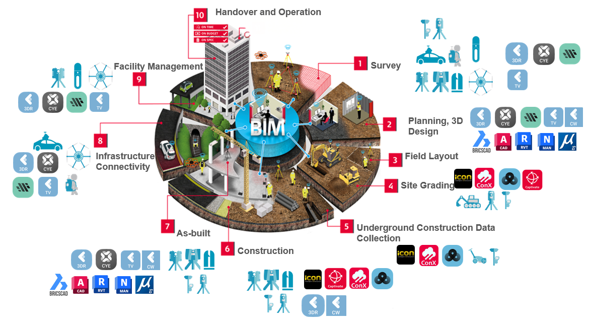
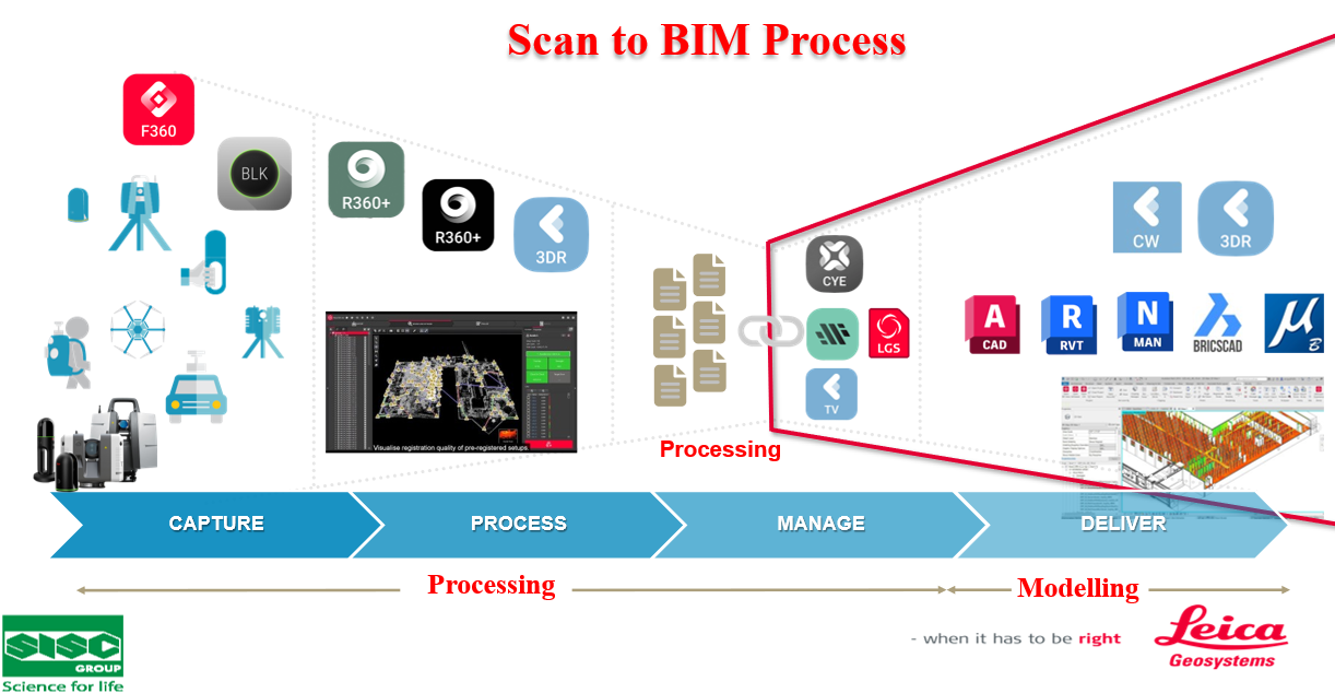
BIM life cycle and hardware, software solutions.
BIM solutions
1. BIM Implementation and Development Solutions
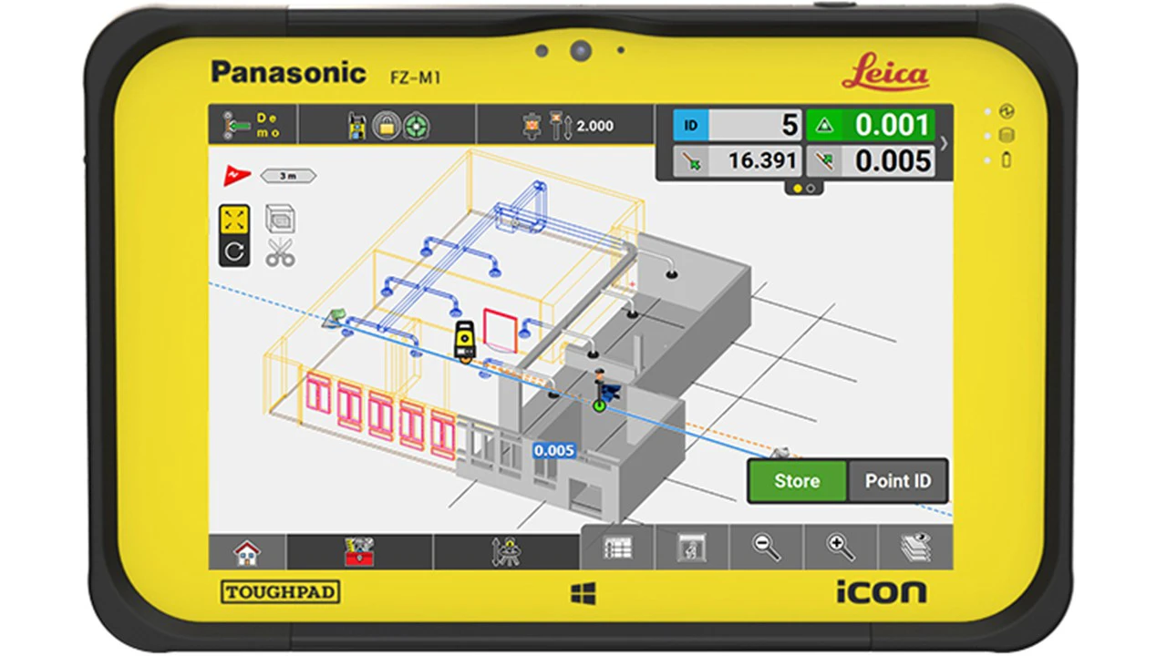
High-precision total stations and GNSS receivers are fundamental to ensuring accuracy and reliability throughout the BIM lifecycle—from initial survey and site grading to construction layout and as-built verification.
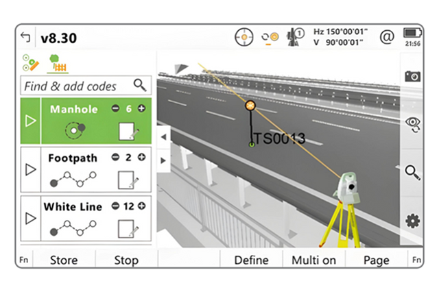
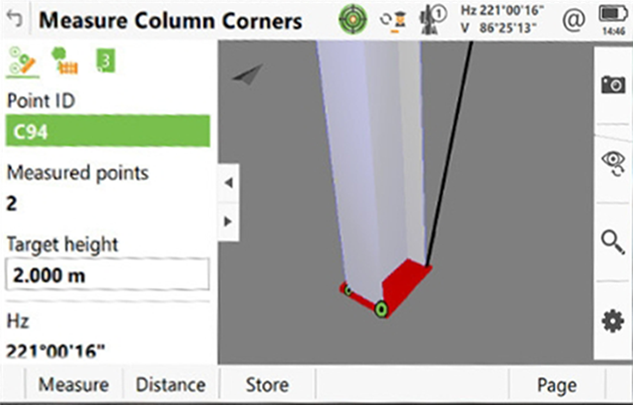
Total Station – The Foundation for High Accuracy
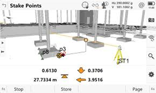
As indispensable tools for surveying and construction, modern total stations are engineered to seamlessly support BIM workflows. They allow for the direct import of 3D BIM models, a crucial capability for precise on-site layout and quality control.
With the ability to accurately measure 3D coordinates, these devices help:
- Design Point Stake-out: Swiftly and accurately transfer data from the BIM model to the field, ensuring the structure is built exactly as designed. This is crucial for correctly positioning all components, from foundations to the roof, preventing errors during construction.
- Quality Assurance: Compare the as-built conditions with the BIM model to detect deviations early, enabling timely adjustments and minimizing risks and costs.
- Detail Data Capture: Perform detailed measurements of components or areas to update the BIM model, essential for creating as-built documentation or for renovation projects.
High-end products with field software now enable seamless transfer of 2D, 3D, and BIM design data (including fully rendered models in IFC format) directly from BIM software to field instrumentation. Intuitive user interfaces and automated, integrated workflows increase productivity.
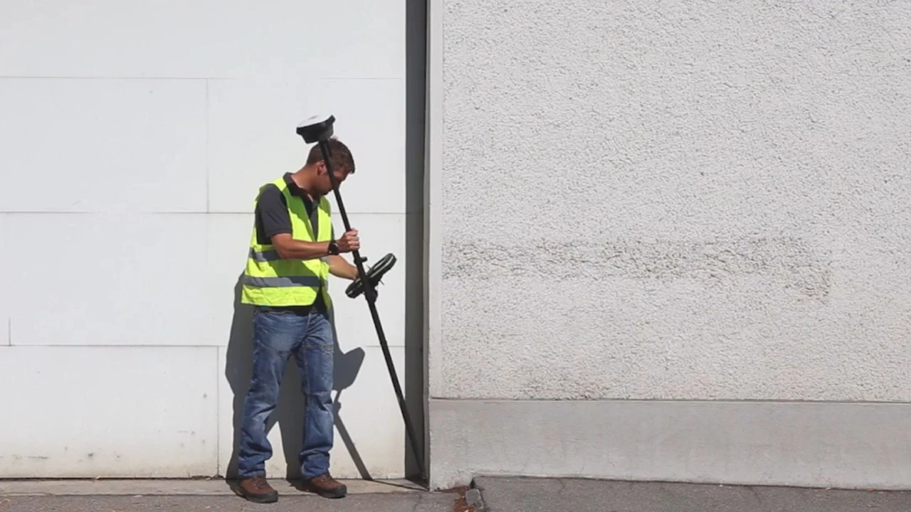
Global Navigation Satellite Systems - GNSS
GNSS devices with RTK or PPK technology deliver centimeter-level and even millimeter accuracy. Today's advanced field software enables seamless work with 3D BIM data directly from office design to field measurements. GNSS devices bring many outstanding benefits in locating construction works.
- Project Control: Establish a high-accuracy control network for the entire construction site, ensuring consistency for all measurement tasks.
- Machine Control: Integrate GNSS into construction machinery (e.g., bulldozers, graders), for precise execution based on the 3D design model, optimizing performance and enhancing safety.
- Large-Scale Topographic Survey: Efficiently collect terrain and feature data as a basis for large-scale BIM creation.
Today, modern solutions incorporate features like tilt compensation, which is immune to magnetic interference, and imaging capabilities, allowing for rapid measurements without needing to level the pole, significantly boosting on-site efficiency.
2. 3D Laser Scanning Solutions (Scan-to-BIM) – From Reality to Digital Model
3D laser scanning is a core technology in the Scan-to-BIM process, enabling the rapid and comprehensive capture of existing conditions. It produces dense, accurate point clouds that serve as the foundation for creating or updating BIM models..
- As-Built Modeling: Quickly generate precise 3D models of existing structures, plants, or infrastructure for renovation, expansion, or asset management.
- Construction Quality Control: Compare the as-built point cloud with the design BIM model to identify deviations, ensuring construction quality and design compliance.
- Operations and Maintenance: Provide a detailed 3D model for planning preventive maintenance, managing assets, and supporting decision-making throughout the building's lifecycle.
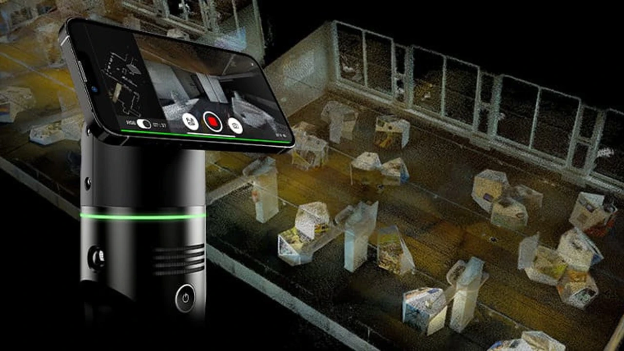
3. Mobile Scan-to-BIM Solutions – Freedom of Movement, Rapid Data Capture
To enhance data capture flexibility and efficiency, advanced mobile scanning solutions allow users to collect high-quality 3D data while on the move.
- Handheld Laser Scanners: These compact, portable devices enable mobile 3D scanning, allowing users to capture entire buildings or complex structures simply by walking through them. They generate high-accuracy, colorized 3D point clouds ideal for as-built modeling and asset management, utilizing SLAM (Simultaneous Localization and Mapping) technology to simplify the workflow..
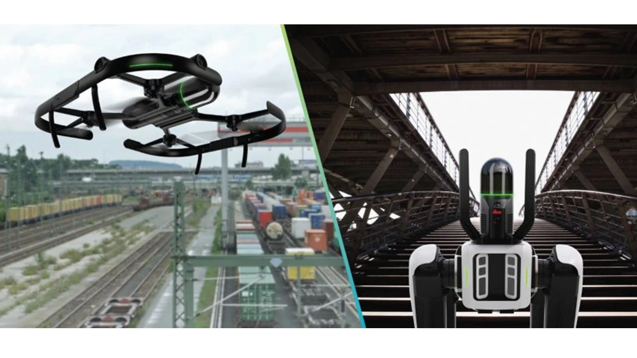
- Aerial 3D Laser Scanning: This solution uses specialized aircraft or unmanned aerial vehicles (UAVs) for aerial 3D laser scanning during survey and as-built stages. UAVs can safely and efficiently scan large areas and hard-to-reach vertical surfaces like building facades and bridges.
- Robotic Integration: Designed for mounting on robots or other mobile platforms, these solutions offer fully autonomous 3D scanning in hazardous or inaccessible environments, providing high-quality data without human intervention.
4. Mobile Mapping: High-Speed Data Acquisition for Complete Corridors
- Mobile Mapping Systems enable high-speed, large-scale 3D data collection, ideal for linear infrastructure projects such as roads, railways, and urban surveys. This technology connects surrounding infrastructure data with the design BIM, enhancing data collection efficiency and linking BIM-GIS models.
- Comprehensive Data Collection: Combines 3D laser scanning, GNSS, and panoramic imagery to produce dense, geo-referenced point clouds and images for urban planning, road asset management, and infrastructure design.
- High Efficiency: Significantly reduces field survey time compared to traditional methods, capturing dozens of kilometers of data in just a few hours.
- Safety: Minimize risks for personnel working in high-traffic or hazardous environments.
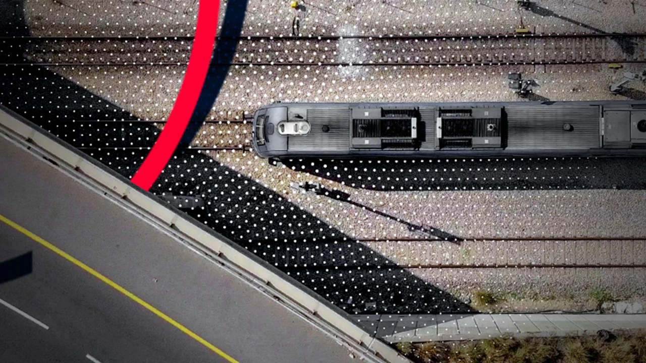
Mobile Mapping Systems provide flexible data collection capabilities, creating complex and detailed infrastructure BIM models, supporting decisions from planning to operations.
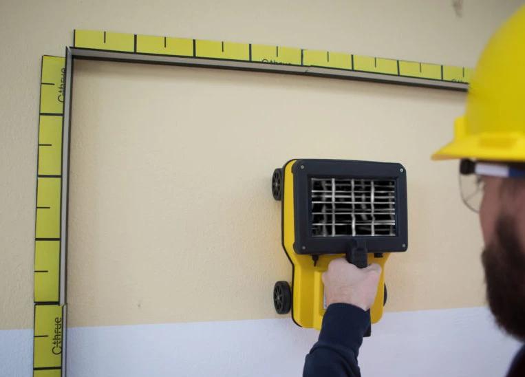
5. Underground Utility Detection Solutions – Unveiling the Subsurface World.
Surveying and managing underground utilities is a major challenge requiring high accuracy and the ability to penetrate the ground. We offer specialized solutions to solve this problem:
- Concrete Scanner: Compact, easy-to-use handheld systems that allow users to see through concrete structures, providing real-time data to make optimal decisions for inspection repair and as-built verification.
- Ground Penetrating Radar - GPR: Using radar waves to detect and map underground utilities such as water pipes, electric cables, gas pipes, etc. without digging. This helps avoid damage to existing structures, ensures worker safety, and minimizes product disruption.
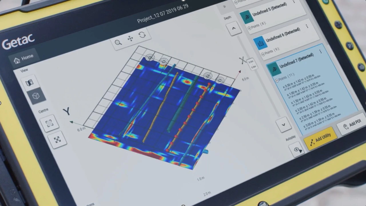
Integrating data from these solutions into the BIM model provides stakeholders with a comprehensive and accurate overview of the subsurface utility network, enabling better decisions in planning, design, and maintenance.
By combining these advanced solutions, users can achieve a seamless BIM workflow, helping professionals increase productivity, minimize errors, and make more informed decisions throughout the project lifecycle. We are committed to delivering leading-edge technology to support our clients' success as the construction industry transitions into the digital age.
Ready to enhance your project's precision and efficiency?
Whether you need details on a specific solution or require a custom configuration for a unique project, our team is here to help. Contact SISC Vietnam Instrumentation JSC today for a comprehensive consultation on our advanced solutions and equipment..
Keywords: BIM, Leica Scan-to-BIM solutions, C-thrue, GPR