SEABED TOPOGRAPHY AND BATHYMETRIC SURVEYING TECHNOLOGY: UNLOCKING THE OCEAN'S MYSTERIES
Beneath the familiar surface of our oceans lies a world of profound mystery—a hidden landscape of vast canyons, towering mountain ranges, and plains sculpted by forces we are only beginning to understand. This is the realm of seabed topography, a challenging frontier that holds the blueprint of our planet's geological history, the location of vital natural resources, and the lingering evidence of cataclysmic ocean events. To pierce this darkness, scientists wield the powerful tools of deep-sea surveying and bathymetric technology, sending pulses of sound and light to meticulously chart the hidden architecture of the ocean floor.
Key technologies employed:
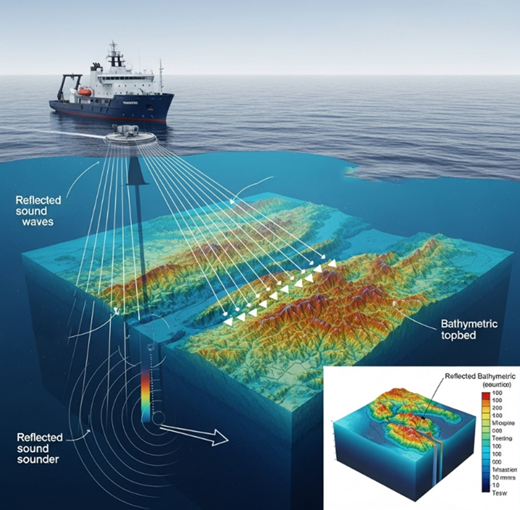
- Sound navigation and ranging (Sonar): This core technology uses sound waves to measure distance from the surface to the seabed.
- Single Beam Echosounder: Provides depth information as a series of points, suitable for linear or small area surveys.
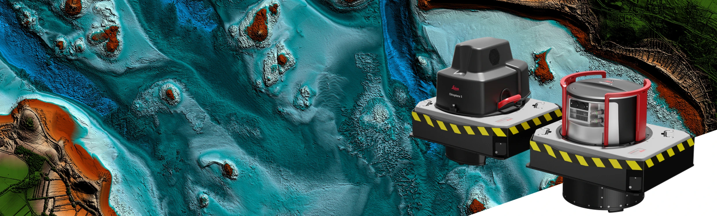
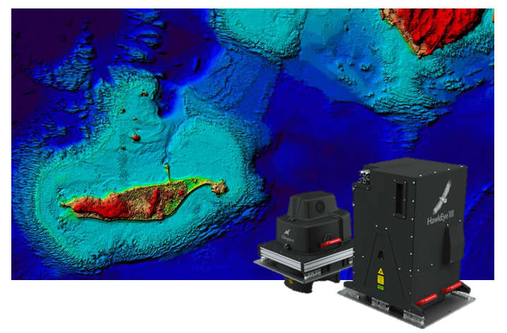
- Multibeam Echosounder: Emit hundreds or thousands of sound beams simultaneously, creating a detailed, high-resolution 3D map of the seabed over a wide swath.
- Global Navigation Satellite Systems (GNSS) combined with Inertial Measurement Unit (IMU): Ensures high accuracy in positioning the survey vessel and orienting the measurement equipment, compensating for vessel motion caused by waves.
- Ancillary sensors: Includes Sound Velocity Profiler - SVP, pressure sensor, and sediment sampling system
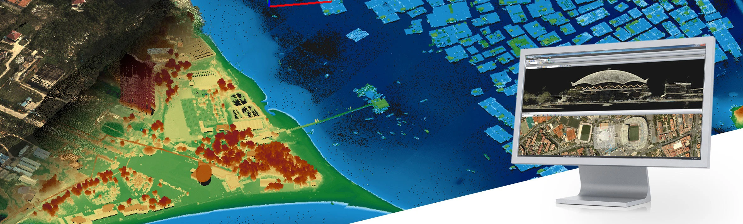
- Seamless Topo-Bathymetric Surveying Solutions: These solutions seamlessly integrate data from terrestrial and marine environments. This provides a comprehensive picture, enabling more accurate and effective decision-making, especially for complex transitional zones like estuaries, coastal areas, and tidal flats where traditional sonar may struggle due to shallow depths or obstructions.
Diverse and Practical Applications
Seabed topography and bathymetric surveying are not just scientific research tools; they have numerous practical applications that contribute significantly to various industries.
1. Maritime:
- Hydrographic Charting: Tạo ra các bản đồ địa hình đáy biển chính xác, cung cấp thông tin về độ sâu, chướng ngại vật (như đá ngầm, xác tàu đắm) giúp tàu thuyền di chuyển an toàn và hiệu quả, đặc biệt tại các cảng biển và luồng hàng hải quan trọng.
- Waterways and Canal design and maintenance: Ensuring sufficient depth for large vessels to access ports, or supporting dredging and maintenance operations.
2. Marine Engineering and Offshore Construction:
- Site Surveys: Providing detailed topographic data for the installation of foundations for structures like oil and gas rigs, offshore wind turbines, submarine cables, and pipelines.
- Design and Construction of Port and Seawalls: Ensuring the stability and safety of marine structures.
- Monitoring Coastal Erosion and Siltation: Monitoring changes in sea level, ocean currents, and the impact of climate change on marine ecosystems.
3. Scientific Research and Ocean Exploration:
- Marine geology research: Understanding tectonic structures, ocean formation processes, and underwater geological features.
- Resource Exploration and Assessment: Identifying potential locations for mineral deposits, gas, and oil beneath the seabed.
- Oceanography and Climate Change Research: Monitoring changes in sea level, ocean currents, and the impact of climate change on marine ecosystems.
4. Maritime Security & Defense:
- Naval Operations Support: Creating detailed maps for underwater missions, including anti-submarine warfare, mine countermeasures, and protection of maritime sovereignty.
Undeniable Importance
The importance of seabed surveys and bathymetric technology is enormous:
- Enhancing Maritime Safety: Minimizing the risk of maritime accidents, protecting human lives and assets.
- Promoting Marine Economic Development: Supporting resource extraction, construction, and maritime trade, contributing to national economic growth.
- Protecting the Marine Environment: Cung cấp dữ liệu quan trọng để theo dõi và quản lý môi trường biển, từ đó đưa ra các chính sách bảo tồn hiệu quả.
- Strengthening science and technology capacity: Khuyến khích nghiên cứu và phát triển các giải pháp tiên tiến, đóng góp vào sự hiểu biết toàn diện về đại dương.
- Protecting National Sovereignty: Providing scientific and legal evidence for defining and protecting maritime zones under national sovereignty, sovereign rights, and jurisdiction.
Seabed topography and bathymetric surveying are not merely academic pursuits; they are the cornerstone of modern marine exploration, management, and sustainable development. As technology accelerates, our ability to render the seafloor in stunning detail grows, transforming abstract data into actionable intelligence. This precision is critical for everything from offshore infrastructure planning and safe navigation to identifying and protecting fragile marine ecosystems.
Realizing this potential demands more than technology—it requires a partner with deep expertise. At SISC Vietnam Instrumentation Joint Stock Company, we equip our clients with industry-leading seabed topography and bathymetric surveying solutions. Contact us to discover how our state-of-the-art equipment and dedicated support can meet the rigorous demands of your projects and drive them toward success.
Keywords: Airborne sensor, Bathymetric, HawkEye-5