EXPLORE THE SUPERIOR POWER OF GEOSPATIAL TECHNOLOGY: SHAPING THE FUTURE WITH LOCATION DATA
In our increasingly data-driven world, the question of 'where' has become paramount. Answering this call, geospatial technology has matured from a specialized tool into a cornerstone of modern strategy, enabling organizations and nations to build a more efficient and sustainable future. It provides a powerful framework for collecting, analyzing, and visualizing location-based information, revealing patterns and insights that were once invisible. From optimizing global supply chains to planning resilient cities, geospatial technology is the key to unlocking a deeper understanding of our planet.
1. Geospatial Data: The Foundation of Intelligent Decisions
This transformative potential is built upon a single, fundamental element: geospatial data. Every action and analysis in the geospatial realm begins with this essential fuel—any piece of information intrinsically linked to a location on Earth. It is the digital footprint of an object, the boundary of an event, or the pattern of a phenomenon. The true power of the technology is unlocked by the rich diversity of this data, which is categorized into various forms that mirror the complex spatial tapestry of the real world:
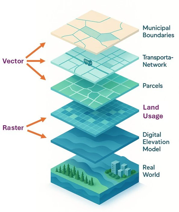
- Point Data: Represents discrete locations of objects. Examples: trees, lamp posts, bus stops, or specific events like accident sites.
- Line Data: Describes linear features. Examples: transportation networks, rivers, pipelines, power lines, or administrative boundaries.
- Polygon Data: Represents enclosed areas with defined boundaries. Examples: administrative boundaries of provinces/cities, residential areas, agricultural lands, forests, or lakes.
- Raster Data: A grid of cells (pixels) where each pixel contains attribute information. The most common examples are satellite imagery or aerial photography, where each pixel has a different color value. Other raster data includes Digital Elevation Models (DEMs), temperature maps, and population density maps.
- 3D Data: An advanced data type that describes not only planar position (X, Y) but also height or depth (Z), creating a virtual model of the physical world. 3D data includes:
- Digital Terrain/Elevation Model (DTM/DEM): Represents the Earth's surface with detailed elevation.
- 3D City Models: Includes buildings, trees, and infrastructure with realistic shapes and heights.
- Point Cloud: A collection of millions of data points with X, Y, Z coordinates and intensity information, typically collected by LiDAR technology, creating a precise digital replica of the environment.
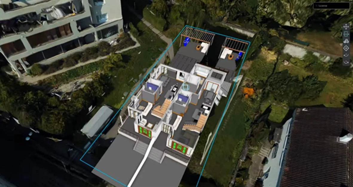
- Building Information Modeling - BIM: A specialized type of 3D data that integrates geometric data with diverse information about materials, structure, cost, and scheduling. BIM creates a comprehensive digital twin of a facility, supporting the entire project lifecycle from design and construction to operation and maintenance.
The connection between attribute data (e.g., name, type, value) and spatial data (geographic location) is what makes geospatial data so powerful. This linkage enables the analysis of an object's relationship with its surrounding environment, providing a comprehensive and insightful view of the world.
2. Advanced Geospatial Technology: Tools Shaping the Future
To fully exploit the potential of geospatial data, a range of specialized technologies have been developed and are continuously improving:
- Geographic Information System – GIS: The heart of geospatial technology. GIS is a comprehensive system for integrating, analyzing, and visualizing diverse data layers to identify trends, patterns, and spatial relationships, supporting evidence-based decision making.
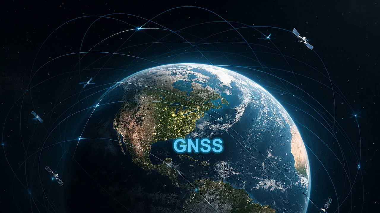
- Global Navigation Positioning System – GNSS: This familiar technology has revolutionized positioning and navigation. Using a satellite network around the Earth, GNSS provides precise coordinates, forming the basis for applications ranging from military and civil navigation, search and rescue, and precision agriculture.
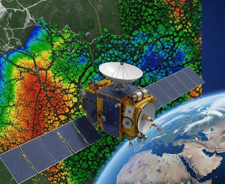
- Remote Sensing: This technique allows for the acquisition of data from a distance without direct contact. Remote sensing utilizes various sensors (optical, radar, thermal) mounted on satellites, manned aircraft, or Unmanned Aerial Vehicle (UAV/drone) to collect data as images or electromagnetic spectrum.
- Light Detection and Ranging – LiDAR: A remote sensing method that uses pulsed laser light to measure distances, creating highly accurate 3D point clouds of the terrain and surface objects. LiDAR is particularly useful for detailed topographic mapping under forest canopies, 3D urban modeling, and power line surveys.
- Unmanned Aerial Vehicle Surveying (UAV/Drone Surveying): The rapid advancement of UAV technology has revolutionized geospatial data collection. Drones can fly at low altitudes to capture very high-resolution data with greater flexibility than satellites or manned aircraft. Equipped with RGB, multispectral, thermal, or LiDAR sensors, drones are widely used in topographic surveying, construction monitoring, precision agriculture, and infrastructure inspection.

3. Diverse Technology of Geospatial Technology
The synergy of geospatial technologies has enabled countless practical applications, profoundly impacting nearly every aspect of society and the economy:
- Urban Management and Planning: Support infrastructure mapping, analyze development models, optimize public transport, and manage urban assets efficiently.
- Smart Agriculture: Enables soil fertility mapping, crop monitoring, and precision farming to increase productivity and reduce environmental impact.
- Resource and Environment Management: Crucial for monitoring climate change, deforestation, water resources, and providing data for disaster prediction and response
- Transportation and Logistics: Supports navigation systems, helping to optimize travel routes, manage vehicles, and enhance supply-chain efficiency.
- Surveying and Construction: Geospatial technology is the backbone of the construction industry, enabling 3D site modelling, geological survey, progress monitoring, and ensuring safe execution of complex projects.
- Security and Defense: Provides critical intelligence, supports border surveillance, strategic mapping, terrain analysis for military operations, and coordination of rescue operations.
- Public Health: Helps track the spread of diseases, identify high-risk area, and plan the effective allocation of medical resources.
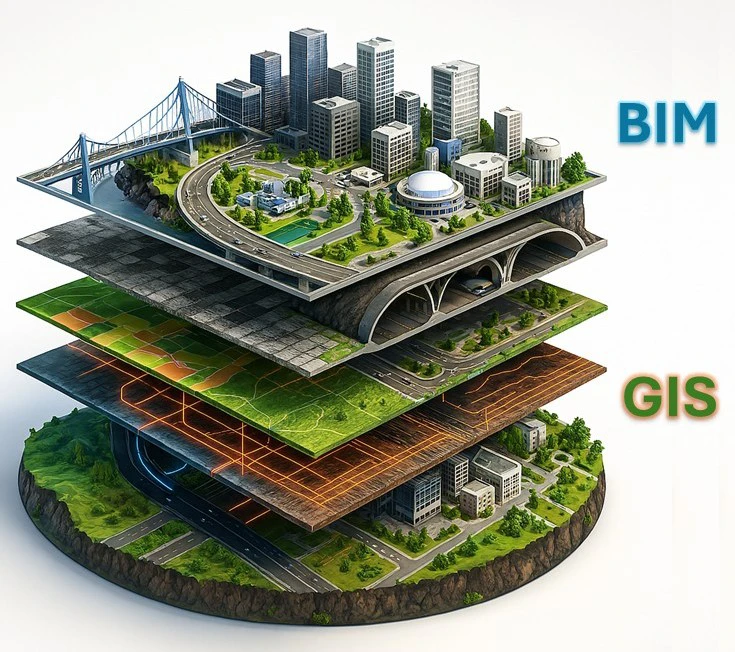
- The BIM-GIS Integration: Elevating Project and Infrastructure Management.
A significant advancement in geospatial technology is the integration of Building Information Modeling (BIM) and Geographic Information System (GIS). While BIM focuses on the detailed structural information within a specific facility, GIS specializes in managing and analyzing data on a board geographic scale.
A Promising Future:
The combination of Artificial Intelligence (AI), Machine Learning, and Big Data is propelling geospatial technology forward – automating the analysis of vast data sets, detecting patterns, and forecasting trends to power smart cities and global resource-management systems.
The BIM-GIS integration offers dual benefit:
- Comprehensive Insight: Connect detailed BIM models of individual buildings, bridges, and pipelines with the broader spatial context of GIS. This enables planners, engineers, and managers to clearly understand the two-way interactions between each project and its surroundings.
- Smarter Decision Making: Allows for analysis of factors like urban drainage, utility network capacity, and environmental impacts on building performance by linking the micro-level (BIM) with the macro-level (GIS).
- Efficient Project Lifecycle Management: From planning and design to operation and maintenance, this integration ensures seamless data management, minimizing errors and optimizing resources.
- Support for Smart City: Provides the foundation for creating comprehensive Digital Twins of cities, connecting all infrastructure, environmental, and population data in real-time for intelligent and sustainable urban management.
In general, the integration of BIM-GIS is more than a technological pairing – it’s a leap in how we manage and optimize construction and infrastructure projects, from local builds to nationwide initiatives. Harnessing the full power of this synergy requires a partner with not only the right technology but also the deep expertise and strategic vision to lead the way..
SISC Vietnam Instrumentation Joint Stock Company is that pioneering leader, delivering advanced geospatial solutions across Vietnam. Backed by a team of highly skilled, experienced, and internationally certified technicians, we provide precise advice to match each user’s needs and offer after-sales services designed to exceed customer expectations. SISC Vietnam is committed to empowering the nation's key industries by transforming complex spatial data into actionable intelligence, enabling our clients to execute their projects with greater precision, efficiency, and foresight.